Moisture makes an appearance in our Seed Genetics Direct Harvest Weather Forecast for the first time this season. A significant weather system develops through the weekend to our west, and by Sunday morning, we will be seeing rain stretch all the way from western Colorado to western Indiana. Through the day Sunday rain spreads east and north, getting into all of Indiana and spreading into Michigan.
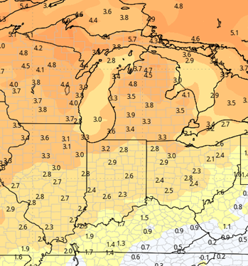
Rain continues off and on over the entire eastern corn belt through Tuesday. Rain totals will end up at 0.5”-2” over 90% of the region. The map below shows our expectations.

There are several periods where we can see thunderstorms. Right now we are not talking up a severe storm threat, but heavier rains can happen in those thunderstorm areas. That will put us in the upper end of the range and even have potential to exceed precipitation targest on a hyper-local level.
Behind the system, we will try and go dry for the rest of the week. However, more clouds hold on in the wake of the moisture. We expect a mix of clouds and sun Wednesday through the weekend. Some data points toward low pressure stalling over eastern Ontario and Quebec, and so several rounds of wrap around moisture cycling back through MI and northern IN. However, we are not fully in that camp. While we may see increased clouds in those areas, we are promoting more of a rain free window, especially in Indiana, Wednesday through Sunday.
Near the end of the 10 day forecast window, we are seeing another system developing in the Northern Rockies, moving into the Northern and Central Plains. That likely will try and throw another round of mositure this direction for late the 30th into the 1st, but timing still is subject to change, as track gets solidified. That system likely does draw down some cooler air behind it.
Extended Period:
The rest of the extended period is dry through the end of the first week of October. Our next significant frontal boundary brings rain showers for the overnight of the 4th into the 5th. Rain totals can be 0.25”-0.75” with 80% coverage. We swing back dry for the end of the 16 day period overnight the 5th into the 6th and follow that pattern into the week of the 7th.

Weeks 3 & 4:
Temperatures stay very elevated through weeks 3 and 4, with well above normal day time highs and nighttime lows. Precipitation should remain below normal for week three, but for the middle of October in week 4, we may sneak back closer to normal. However, there is no overabundance of rain in the pattern at least into the 3rd week of October.
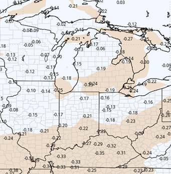
Week 3
Precipitation (green: above normal, brown: below)
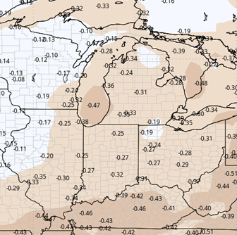
Temperatures (blue: below normal, orange: above)
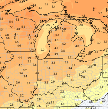
Week 4
Precipitation (green: above normal, brown: below)
Temperatures (blue: below normal, orange: above)