A pattern change is on the way to the eastern corn belt in the Seed Genetics Direct Harvest Weather Forecast.
After several weeks of warm weather, we will have cold air on the move. The result will be some moisture for the weekend potentially in the northern third of Indiana and most of Michigan, and then near to a bit below normal temps for 3 days to start next week. However, we bounce back quickly and will be above normal but the second half of next week and for the extended period.
Saturday features increasing clouds in the north. Scattered showers can break out in the afternoon and evening over the northern third of Indiana, and in lower MI south of I-96. Rain totals can be all over the place, with potential for just a few hundredths up to 0.75” if conditions are ripe for thunderstorms. The cold air is not here yet, and this moisture is just a bit of a front-running disturbance. Central and southern IN should stay dry along with central and northern MI.
Overnight Saturday night, clouds build into more of MI and the main body of the low pressure system kicks out to the east. Showers are likely over all of MI Sunday, while IN just sees clouds in the north and perhaps a few sprinkles. The father south you go, the better potential for sunshine on Sunday.
The heart of the cold air arrives overnight Sunday night into Monday. We expect strong north winds through Monday, such that lake effect clouds and precipitation is likely in northern and especially NW IN, along with the far western side of MI. Moisture is not big…just spits and sprinkles. We also anticipate frost and freeze conditions. Drying should be “ok” during the stretch, but not quite as high of evaporation rates due to the cooler temps.
We get on the backside of Canadian high pressure for the second half of the week and should be sunny, warm, and dry for Thursday through the weekend. Temps are back to above normal, drying fast. We are watching a front develop for the plains next weekend, but we stay rain free through early next Monday morning.
Extended Period:
The extended forecast window features a bit of scattered shower action later Monday afternoon with rain totals up to half an inch but coverage only 60%. The front in the plains falls apart as it moves eastward. The rest of the week and following weekend should remain mostly dry, with temps near normal.

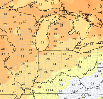
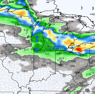
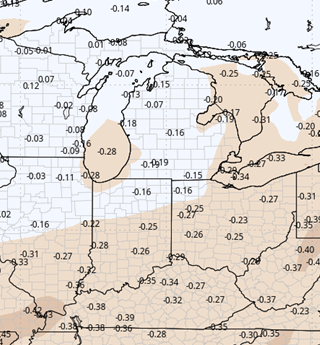
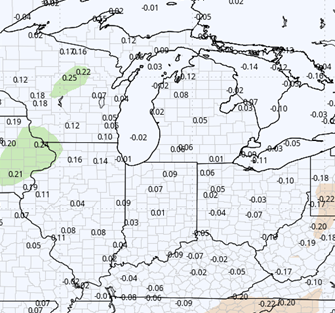
Weeks 3 & 4:
Very warm for week three, compared to normal, and a bit above normal for week 4. Precipitation is below normal for week 3 but will start to sneak back to near normal as we move into the first half of November.
Week 3
Precipitation (green: above normal, brown: below)
Temperatures (blue: below normal, orange: above)
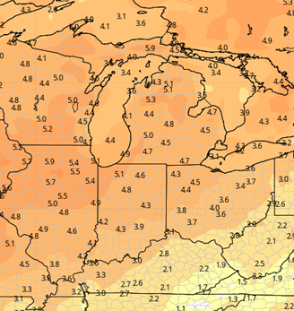
Week 4
Precipitation (green: above normal, brown: below)
Temperatures (blue: below normal, orange: above)