
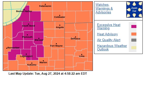
EXCESSIVE HEAT WARNING: Berrien and Cass counties in SW Michigan, LaPorte, St. Joseph, Elkhart, Starke, Pulaski, Marshall, Fulton and Kosciusko counties in Indiana. (HEAT INDEX VALUES 105+)
HEAT ADVISORY: St. Joe (MI), Lagrange in (N. IN) (HEAT INDEX VALUES 100-105)** FROM 11AM – 10PM TUESDAY FOR ALL
On Tuesday, Aug. 27, we could meet or beat the record high temperature of 96 set in 1948. Even if we do not reach the record, Tuesday will feel like the lower 100s to near 100 due to humidity. With this heat, it is important to drink plenty of water and spend as much time in the shade as possible if you need to be outdoors! Tuesday will be the hottest day, but the extreme heat is here through Wednesday.
We do see a few chances of rain this week. The best chances for thunderstorms will be Tuesday evening and Wednesday. A weak front looks like it could come in late Tuesday, giving us the chance for some showers and storms. Some storms could be strong to severe. As of now, our main concerns look to be gusty winds, lightning, and heavy downpours.
Behind this, temperatures cool slightly into the mid-80s by Thursday still with a bit of humidity.
A better chance for showers looks like it will arrive with another front likely Thursday and Friday. Once this arrives we should drop back to highs near 80 for the weekend.